Shorelines
Department of Ecology's Public Comment Period
Ecology Public Comments on Island County SMP
Locally Approved Shoreline Master Program
Locally Approved Shoreline Master Program
Shoreline Permitting
The Washington State Legislature passed the Shoreline Management Act (SMA) in 1971 with the overarching goal of preventing shoreline degradation by uncoordinated development. Island County's Shoreline Master Program (SMP) regulates shorelines, including all marine waters surrounding Whidbey, Camano, and smaller islands, and lakes 20 acres or larger. There are no SMA regulated streams within the county.
Shoreline jurisdiction extends to associated upland areas. These areas, called shorelands, include lands extending 200 feet from the ordinary high-water mark (OHWM) as well as associated wetlands and floodplains.
Island County generally requires review and approval for most regulated activity, including:
Land disturbing activities
- New construction, and exterior alteration of existing structures
- Shoreline stabilization (bulkheads and soft shore)
- Vegetation removal and/or management
- Construction of piers and docks
- Placement of mooring buoys
- Dividing land
- Altering regulated critical areas
- Creating or replacing impervious surfaces
- Changing levels, temperatures, or chemical characteristics of wetlands or waterbodies.
The Shoreline and Your Development
Step 1 - Determine if Your Property is in Shoreline Jurisdiction
Shoreline jurisdiction extends to associated upland areas. These areas, called shorelands, include lands extending 200 feet from the ordinary high water mark (OHWM) as well as associated wetlands and floodplains. Island County's shoreline regulations apply to some freshwater lakes too. Specifically, Deer Lake, Goss Lake, Lone Lake and Cranberry Lake.
Homeowner Brochure (pdf)
Consultant Contractor Guide (pdf)
Step 2 - Determine Your Shoreline Environment Designation (SED)
The Shoreline Master Program (SMP) is tailored to the unique ecosystems and development patterns of Island County. Shoreline uses are identified as either permitted, conditional, or prohibited uses depending on the shoreline environment designation (SED). Each SED has its own permitting and marine buffer/setback standards.
Follow these instructions to determine what SED your property is in:
- Click Here to access IC Geo Map.
- Once you pull up the map, you can type your parcel number or address into the search bar.
- Then click the layers button at the bottom left of your screen.
- Check the box next to shorelines, and click the plus sign to expand the options below.
- Turn on the appropriate layer by clicking the box next to shoreline environment designation.
- Your property should be highlighted in a certain color and labeled as:
- Aquatic
- Natural
- Rural Conservancy
- Shoreline Residential
- Sub-category: Historic Beach Community
- Sub-category: Canal Community
- Urban Conservancy
- High Intensity
Your Marine Waterfront (pdf)
Step 3 - Identify What Type of Permit You May Need
Follow these instructions to determine what permit type your proposed development may require:
- Visit ICC 17.05A.080 here
- On the left side of the table is the list of development types.
- On the top of the table are the SEDs.
- P = Permitted
- C = Conditional
- X = Prohibited
- If your use is Conditional, you will need a Shoreline Conditional Use Permit
- If your use is Permitted check here to see if it meets the criteria of ICC 17.05A.130.E (scroll down to letter E)
- If it does meet the criteria, you will need a Substantial Development Permit
- If it does not meet the criteria, you will need a Shoreline Exemption
- Your development may qualify for a Limited Review Shoreline Exemption, which is an expedited process. Check to see here
Homeowner Beach Access Structures
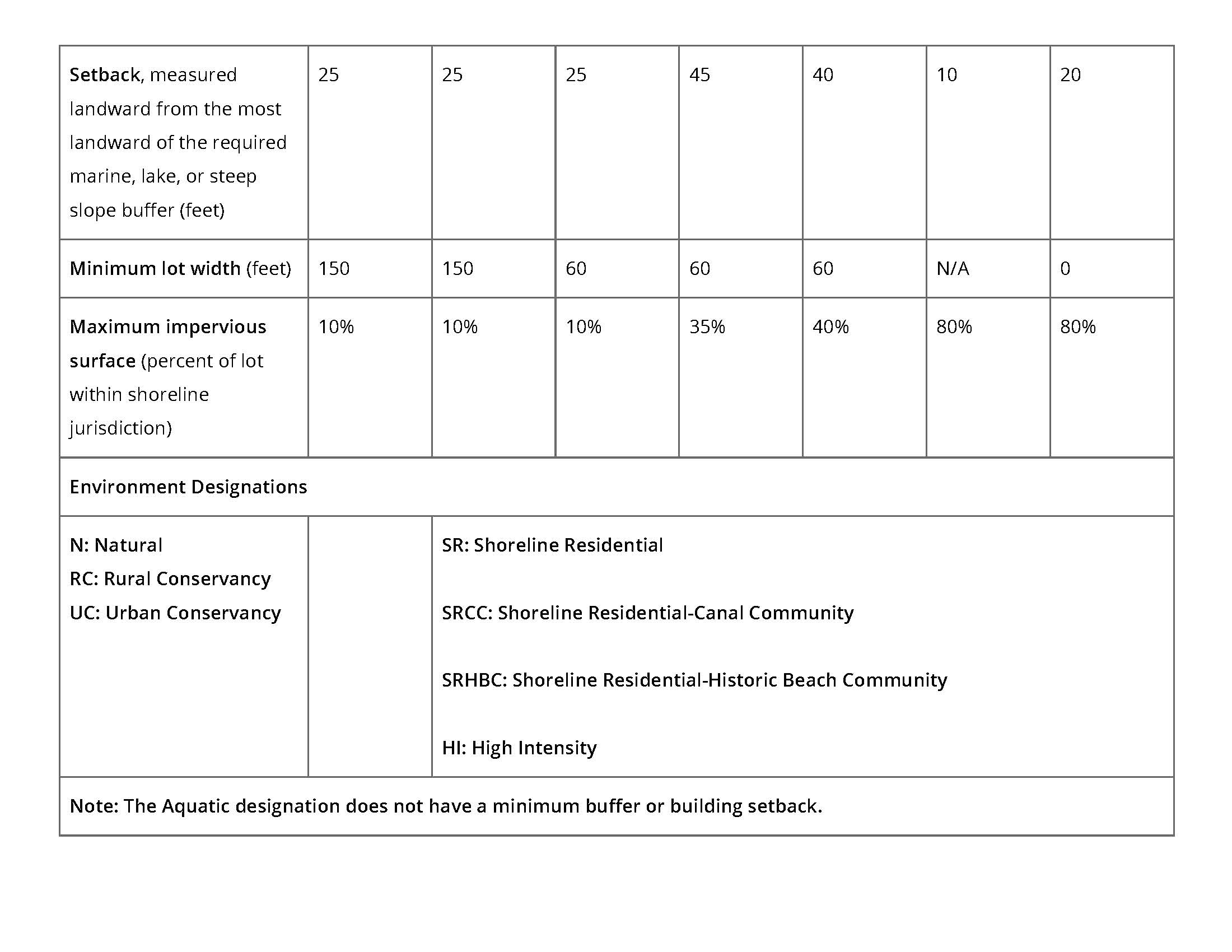
Step 4 - Review the Required Buffers, Setbacks and Impervious Surface Limits for Your SED
Review the table below which can also be found in ICC 17.05A.090 to understand how far your development needs to be setback and what the impervious surface limits are.
 Step 5 - Talk to a Planner
Additional reports may be required to be submitted with your shoreline permit, including:
- An Archaeological Report if your property is in the vicinity of cultural resources
- A Geotechnical Report if your property has steep or unstable slopes
- A Wetland Report or Biological Site Assessment if your property is affected by critical areas or your proposal is in the Marine Buffer
- A Geocoastal Report if you are proposing shoreline stabilization
- A SEPA checklist if your project is in the Marine Buffer, lands covered by water, or a Fish and Wildlife Habitat Conservation Area
- Visit our office to speak with a planner anytime between 8 am and 4:30 pm Monday-Friday.
Or you can email the planner on duty at: PlanningDept@islandcountywa.gov. In your email, please include your parcel number or address and a brief description of your proposal.